

Introduction
Coastal geological wonders are natural formations shaped by Earth’s powerful forces. Waves, volcanic activity, erosion, tectonic movement, and weathering have created some remarkable landscapes along the world’s shores.
Some rise as towering sea cliffs. Others appear as giant rock pillars, sea stacks, arches, caves, or unusual boulders. Many took millions of years to develop.
What makes these places special is their combination of geology and scenery. You can see Earth’s geological history while exploring a coastline.
This guide explores 25 of the best coastal geological wonders in the world. The list includes famous sites and lesser-known formations across several continents.
You’ll discover ancient volcanic landscapes, wave-carved cliffs, dramatic sea stacks, coastal caves, and unusual rock formations. Each destination also has its own story of how nature shaped it.
Along the way, you’ll learn what makes each site geologically important. You’ll also find useful travel information to help plan a visit.
Whether you love natural wonders, photography, road trips, or geology, these coastlines offer something memorable. They show that some of Earth’s most fascinating landscapes are found where land meets sea.
List of 25 Best Coastal Geological Wonders in the World: Quick Glance:
| Coastal Wonder | Country | Geological Type | Best For |
| Giant’s Causeway | Northern Ireland | Basalt columns | Volcanic geology |
| Twelve Apostles | Australia | Sea stacks | Road trips |
| Cliffs of Moher | Ireland | Coastal cliffs | Scenic views |
| Fingal’s Cave | Scotland | Sea cave, basalt | Geology |
| Reynisdrangar | Iceland | Sea stacks | Photography |
What Are Coastal Geological Wonders?
Coastal geological wonders are natural formations shaped by Earth’s geological forces. They occur where land meets the sea and often reveal how landscapes change over vast periods.
Some are formed by ancient volcanic eruptions. Others develop through erosion, tectonic movement, sedimentation, or constant wave action.
The result can be dramatic. Coastal geology creates towering cliffs, sea stacks, arches, caves, rock pillars, beaches, and unusual boulders.
How Coastal Geological Formations Are Created
Coastal formations rarely have a single cause. Several geological processes can work together over thousands or millions of years.
Erosion: Waves, wind, and rain gradually wear down exposed rock. Softer layers usually disappear faster than harder rock.
Volcanic activity: Lava can cool into striking coastal formations. Basalt columns, cliffs, and volcanic islands are common examples.
Tectonic movement: Earth’s crust can rise, sink, fold, or fracture. These movements can create cliffs, raised shorelines, and unusual coastal landscapes.
Sedimentation: Sand, mud, shells, and other materials can accumulate over time. Pressure eventually turns these sediments into sedimentary rock.
Weathering: Water, salt, temperature changes, and other forces slowly break down exposed rock. Weathering can create unusual shapes and textures.
Wave action: Waves repeatedly strike coastal rocks. Over time, they can carve caves, arches, cliffs, and sea stacks.
These processes often overlap. A volcanic rock formation may later be reshaped by waves and weathering.
Geological Age of Coastal Geological Wonders
The rocks behind these coastal wonders formed at very different times in Earth’s history. Geological age can help explain why a landscape looks the way it does, but the age of the rock is not necessarily the age of the visible landform.
| Destination | Geological age worth mentioning | Why it helps |
| Giant’s Causeway | ~60 million years | Explains its Paleogene volcanic origin |
| Twelve Apostles | Miocene limestone; present stacks are much younger | Separates the age of the limestone from the much younger erosional stacks. |
| Cliffs of Moher | ~320 million years | Shows the great age of its sedimentary rocks |
| Fingal’s Cave | ~60 million years | Connects it with the same volcanic episode as Giant’s Causeway |
| Reynisfjara | Relatively young volcanic rocks | Useful, but an exact age is not essential |
| Étretat Cliffs | Cretaceous, roughly 80–100 million years | Helps explain the chalk geology |
| Durdle Door | Jurassic, roughly 150 million years | Important because it forms part of the Jurassic Coast |
| Jurassic Coast | ~250–66 million years | Essential to understanding its geological significance |
| White Cliffs of Dover | Cretaceous, roughly 70–100 million years | Explains the chalk and ancient marine environment |
| Benagil Cave | Mesozoic limestone | Useful, but an exact age is not essential |
| Pancake Rocks | Oligocene, roughly 30 million years | Helps explain the limestone formation |
| Moeraki Boulders | Paleocene–Eocene host sediments | Helps explain their geological setting |
| Bombo Headland | Late Permian, ~250 million years | Places the volcanic rocks in the Late Permian rather than the Cenozoic. |
| Kiama Blowhole | ~260 million years | Highlights the age of its volcanic rocks |
| Varkala Cliffs | Mio-Pliocene | Important to its distinctive sedimentary geology |
| St. Mary’s Islands | Late Cretaceous, roughly 85–88 million years | Adds significant geological context |
| Yehliu Geopark | Miocene sedimentary rocks | Helps explain its weathered formations |
| Los Gigantes | Quaternary volcanic history | Useful for understanding its volcanic landscape |
| Old Man of Hoy | Devonian, ~400 million years | Provides an excellent example of ancient coastal rock |
| Cathedral Rocks | Ancient volcanic rocks | Useful, but exact dating should be verified |
| Algarve formations | Mesozoic–Cenozoic | Useful for understanding the regional geology |
| Praia da Marinha | Mesozoic limestone | Helps explain its cliffs and arches |
| Great Ocean Road formations | Mainly Cenozoic; rock ages vary by formation | Useful, particularly for the Shipwreck Coast |
| Cape Perpetua | Late Eocene volcanic rocks, roughly 40–35 million years | Corrects the volcanic age and links it to the coastal basalt. |
| Big Sur Coast | Multiple geological ages | Reflects its complex tectonic history |
An important distinction: the rock beneath a coastal wonder may be hundreds of millions of years old, while the cave, arch, sea stack, or cliff visible today may have developed much more recently through erosion and weathering.
This difference is central to understanding coastal geology. Ancient rocks can continue to be reshaped by waves and other forces happening today.
Rock Types Behind Coastal Geological Wonders
The rock beneath a coastline strongly influences how it erodes. Hard and resistant rocks can survive as pillars, while weaker layers often form caves, coves, or lower cliffs.
Basalt and other volcanic rocks: Cooling lava can form strong joints and columns. Giant’s Causeway, Fingal’s Cave, Bombo Headland, and Kiama show different volcanic coastal expressions.
Limestone and chalk: These sedimentary rocks can preserve fossils and develop caves, arches, cliffs, and stacks. The Twelve Apostles, Durdle Door, Benagil, and Dover are useful examples.
Sandstone, shale, and other sedimentary rocks: Layered rocks can record ancient environments while erosion exposes their structure. The Cliffs of Moher and Old Man of Hoy show how different sedimentary rocks behave at the coast.
Tectonically complex rocks: Some coasts owe their character to uplift, faulting, fractured bedrock, and landslides as well as marine erosion. Big Sur is a strong example of this combined process.
Why These Coastal Wonders Are Worth Visiting
Coastal geological wonders offer more than spectacular views. They let travelers see geological processes written directly into the landscape.
A sea stack can reveal how erosion changed a former cliff. A basalt formation can preserve evidence of ancient volcanic activity.
They also create memorable travel experiences. Many geological sites offer hiking trails, scenic viewpoints, boat tours, beaches, or dramatic road-trip stops.
For photographers, these landscapes provide constantly changing conditions. Sunrise, sunset, tides, clouds, and weather can transform the same formation throughout the day.
Coastal Geological Wonders vs. Ordinary Coastal Landscapes
Not every beautiful coastline is a geological wonder.
A scenic beach may be attractive without having unusual geological importance. Likewise, a dramatic cliff does not automatically qualify for this list.
For this guide, a coastal geological wonder needs to have a distinctive geological feature or formation. It should also have a clear connection to geological processes such as volcanism, erosion, tectonic activity, sedimentation, or weathering.
We also consider its travel appeal and visual significance. The best examples combine geological interest, natural beauty, and a worthwhile visitor experience.
That standard helps separate genuine geological wonders from ordinary scenic coastlines.
Important Safety Note
Coastal geological wonders can be dangerous, even during good weather. Cliffs, sea caves, rock platforms, beaches, and sea stacks are exposed to changing tides, powerful waves, falling rocks, and unstable ground.
Before visiting, check local weather, tide times, sea conditions, access restrictions, and official safety advice. Stay behind barriers and on marked trails, and never approach the water simply for a better photograph.
Some locations, including Reynisfjara Beach, Cape Perpetua, and exposed coastal cliffs, require particular caution. Conditions can change quickly, so always follow local warnings and instructions.
How We Selected These Wonders
Not every beautiful coastline qualifies as a geological wonder. For this list, we focused on places where the landscape reveals a distinctive geological story.
We considered several factors when selecting the 25 sites:
- Geological significance: Each location has a notable rock type, landform, geological process, or geological history.
- Distinctive formations: We favored unusual cliffs, sea stacks, caves, arches, basalt columns, blowholes, and other recognizable formations.
- Travel value: The site should offer a worthwhile experience for travelers, photographers, nature lovers, or geology enthusiasts.
- Variety: The list includes different rock types and formation processes from several regions of the world.
- Visitor experience: Accessibility, viewpoints, trails, and opportunities to understand the landscape were also considered where relevant.
The numbering is not a scientific ranking of geological importance. It is a curated travel selection designed to showcase different coastal landforms, rock types, geological processes, and visitor experiences.
Some formations developed through volcanic activity. Others resulted from sedimentation, tectonic movement, weathering, or millions of years of wave erosion.
Together, they show how dramatically Earth’s geology can shape the places where land meets sea.
Quick Comparison Table of 25 Best Coastal Geological Wonders in the World
| Coastal Geological Wonder | Location | Geological Feature | Main Formation Process | Best For |
| Giant’s Causeway | Northern Ireland | Basalt columns | Volcanism and cooling | Volcanic geology |
| Twelve Apostles | Australia | Limestone sea stacks | Wave erosion of limestone | Road trips |
| Cliffs of Moher | Ireland | Sedimentary cliffs | Sedimentation and marine erosion | Scenic views |
| Fingal’s Cave | Scotland | Basalt cave | Volcanism and wave erosion | Geology lovers |
| Reynisfjara | Iceland | Basalt stacks and black sand | Volcanism and coastal erosion | Photography |
| Étretat Cliffs | France | Chalk cliffs and arches | Chalk erosion and weathering | Photography |
| Durdle Door | England | Limestone sea arch | Wave erosion and differential erosion | Coastal walks |
| Jurassic Coast | England | Fossils and sedimentary rocks | Sedimentation, tectonics and erosion | Geology |
| White Cliffs of Dover | England | Chalk cliffs | Marine chalk deposition and erosion | Easy sightseeing |
| Benagil Cave | Portugal | Limestone sea cave | Limestone dissolution and wave erosion | Boat trips |
| Pancake Rocks | New Zealand | Layered limestone | Limestone formation, uplift and erosion | Geology |
| Moeraki Boulders | New Zealand | Coastal concretions | Concretion growth and coastal erosion | Photography |
| Bombo Headland | Australia | Basalt columns | Volcanism, jointing and erosion | Geology |
| Kiama Blowhole | Australia | Volcanic coastal blowhole | Wave erosion of volcanic rock | Families |
| Varkala Cliffs | India | Sedimentary cliffs | Sedimentation, uplift and erosion | Beach and geology |
| St. Mary’s Islands | India | Columnar basalt | Volcanic cooling and coastal erosion | Geological heritage |
| Yehliu Geopark | Taiwan | Weathered sedimentary rocks | Differential weathering and wave erosion | Photography |
| Los Gigantes | Spain | Volcanic cliffs | Volcanic construction and erosion | Scenic cruises |
| Old Man of Hoy | Scotland | Sandstone sea stack | Wave erosion of sandstone | Adventure |
| Cathedral Rocks | Australia | Coastal volcanic formations | Volcanic rock erosion | Photography |
| Algarve Coast | Portugal | Limestone formations | Limestone erosion and weathering | Coastal exploration |
| Praia da Marinha | Portugal | Limestone arches and stacks | Limestone erosion and weathering | Easy sightseeing |
| Great Ocean Road | Australia | Limestone coastal formations | Marine erosion of limestone | Road trips |
| Cape Perpetua | USA | Basalt coast and sea caves | Volcanism, uplift and wave erosion | Adventure |
| Big Sur | USA | Tectonic coastal landscape | Coastal erosion and weathering | Road trips |
25 Best Coastal Geological Wonders in the World
From towering sea cliffs to ancient volcanic formations, the world’s coastlines hold remarkable geological treasures. Some were shaped by lava, while others took millions of years of erosion to form.
The 25 coastal geological wonders below were selected for their distinctive geology, natural beauty, and travel appeal. Each one shows how powerful natural forces can transform rock along the world’s shores.
You’ll find famous landmarks alongside less familiar geological sites. Together, they span several continents and showcase cliffs, sea stacks, basalt columns, caves, arches, boulders, and other unusual coastal formations.
For each destination, we’ll explain its geological significance, how it formed, where to find it, the best time to visit, and practical safety considerations.
Let’s begin with one of the world’s most recognizable geological coastlines.
1. Giant’s Causeway, Northern Ireland
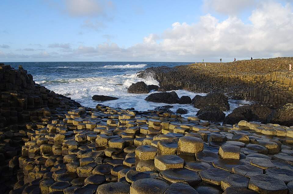 Giant’s Causeway is one of the world’s most remarkable coastal geological formations. Its shoreline is covered with thousands of closely packed basalt columns, creating an almost geometric landscape beside the North Atlantic.
Geological significance:
The columns are a spectacular example of columnar basalt, a volcanic rock formation. Many columns have five or six sides, although their shapes and sizes vary. The formation is part of a much larger volcanic landscape along Northern Ireland’s north coast.
How it formed:
Around 60 million years ago, lava flowed across this region during intense volcanic activity. As the thick lava cooled, it contracted and developed cracks. Those cracks gradually extended through the rock, producing the distinctive columns seen today.
Where is it?
Giant’s Causeway lies on the County Antrim coast of Northern Ireland, near the town of Bushmills. It forms part of the Causeway Coast, a spectacular stretch of coastline known for cliffs, sea caves, beaches, and other geological features.
Best time to visit:
Late spring through early autumn usually offers the most comfortable conditions for exploring the coast. Early mornings and later afternoons can provide softer light and fewer visitors.
What to see nearby:
The surrounding Causeway Coast has several worthwhile stops. Dunluce Castle, Carrick-a-Rede Rope Bridge, and the dramatic coastal cliffs are among the most popular.
Visitor tips:
Wear shoes with good grip because the basalt columns can be uneven and slippery. Stay within designated areas and follow local safety advice, especially near the water and cliff edges.
Giant’s Causeway is more than a striking coastal landmark. It is a visible record of ancient volcanic activity, making it an ideal starting point for this journey through the world’s coastal geological wonders.
2. Twelve Apostles, Australia
The Twelve Apostles are among Australia’s most famous coastal rock formations. The name is historical; only seven stacks remain in the main group after collapses. These towering limestone stacks rise from the Southern Ocean along the spectacular Great Ocean Road.
Geological significance:
The stacks are remnants of the mainland cliffs that once extended along this coast. They are made mainly of limestone formed from marine sediments. The limestone is much older than the present-day stacks, which are products of relatively recent coastal erosion. Their dramatic shapes show the long-term power of coastal erosion.
How it formed:
Waves gradually attacked weaknesses in the limestone cliffs. Over time, caves formed in the cliff walls and eventually became arches. Continued erosion caused the arches to collapse, leaving isolated rock stacks offshore.
The process is still happening today. Wind and waves continue to wear down the remaining stacks, slowly changing their shapes.
Where is it?
The Twelve Apostles are on Victoria’s Great Ocean Road, about 275 kilometers southwest of Melbourne. The formations are part of the Port Campbell National Park and sit along one of Australia’s most scenic coastal drives.
Best time to visit:
The coast can be visited throughout the year. Spring and autumn often offer comfortable conditions, while early morning and late afternoon provide excellent light for photography.
What to see nearby:
Don’t stop at the Twelve Apostles alone. Loch Ard Gorge, London Bridge, The Grotto, and other formations along the Shipwreck Coast reveal more of the region’s dramatic geology.
Visitor tips:
Use the designated viewing areas and stay behind safety barriers. Strong winds and sudden waves can make the coastline dangerous, even when conditions appear calm.
The Twelve Apostles are a powerful reminder that coastal landscapes are never truly finished. Erosion continues to reshape this limestone coast, just as it has done for millions of years.
3. Cliffs of Moher, Ireland
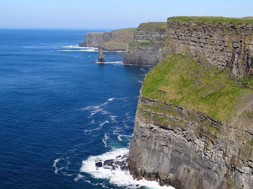 The Cliffs of Moher are one of Ireland’s most dramatic coastal landscapes. Rising high above the Atlantic Ocean, these dark cliffs stretch for about 14 kilometers along County Clare.
Geological significance:
The cliffs are mainly made of shale, siltstone, and sandstone. Their exposed layers record sediments deposited in an ancient deltaic and marine setting. These rock layers provide a visible record of geological changes that occurred more than 300 million years ago.
How it formed:
The rocks formed from sediments that accumulated in an ancient river and delta system. Over immense periods, these sediments were compacted and hardened into rock.
Later, the Atlantic Ocean began carving into the coastline. Waves exploited cracks and weaker sections, gradually creating the steep cliffs, caves, and offshore sea stacks visible today.
Where is it?
The Cliffs of Moher are on Ireland’s County Clare coast, overlooking the Atlantic. They form part of the Burren region and lie about 75 kilometers southwest of Galway.
Best time to visit:
Late spring and early autumn can offer a good balance of milder weather and fewer crowds. Clear days provide the best views, but the cliffs remain impressive in changing weather.
What to see nearby:
The Burren is an excellent addition to a visit. Its unusual limestone landscape provides a striking contrast to the sandstone and shale cliffs. Doolin and nearby coastal viewpoints are also worth exploring.
Visitor tips:
Weather can change quickly along the exposed cliffs. Wear sturdy footwear and stay behind marked safety barriers, especially during strong winds.
The Cliffs of Moher are more than a spectacular viewpoint. Their exposed rock layers allow visitors to see hundreds of millions of years of geological history written into an Atlantic coastline.
4. Fingal’s Cave, Scotland
Fingal’s Cave is a remarkable sea cave on the uninhabited island of Staffa, off Scotland’s west coast. Its towering basalt columns form a natural entrance that looks almost architectural.
Geological significance:
The cave is carved into a mass of hexagonal basalt columns. These columns are part of an ancient volcanic landscape shared with nearby geological formations, including Northern Ireland’s Giant’s Causeway.
How it formed:
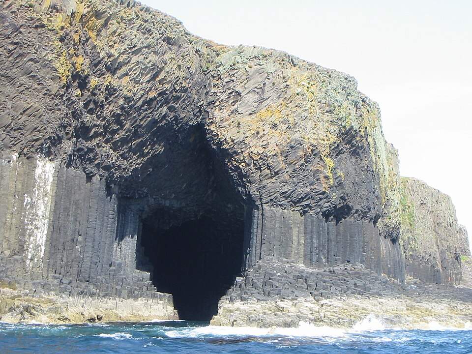 The basalt formed when thick lava flows cooled millions of years ago. As the lava contracted, it developed regular cracks that extended through the rock.
Over time, Atlantic waves exploited weaknesses between the columns. Continued erosion created the large sea cave seen today, while leaving the distinctive column structure exposed.
Where is it?
Fingal’s Cave is on Staffa, part of Scotland’s Inner Hebrides. The island lies west of the mainland and north of the Isle of Mull.
Best time to visit:
The warmer months generally offer the best opportunity for boat trips. Sea conditions can change quickly, however, so cave landings depend on weather and swell conditions.
What to see nearby:
Staffa itself is the main attraction, with basalt columns surrounding much of the island’s coastline. Iona and the Isle of Mull can also be combined with a wider trip through Scotland’s Inner Hebrides.
Visitor tips:
Access depends heavily on sea conditions. If landing is possible, take care on the uneven basalt surface and follow the operator’s safety instructions.
Fingal’s Cave shows how volcanic rock and coastal erosion can work together. The result is a dramatic sea cave with one of Scotland’s most unusual natural entrances.
5. Reynisfjara and Reynisdrangar, Iceland
Reynisfjara is a striking black-sand beach on Iceland’s southern coast. Just offshore, the jagged Reynisdrangar sea stacks rise from the Atlantic, creating one of Iceland’s most unusual coastal landscapes.
Geological significance:
The coastline combines black volcanic sand, basalt columns, sea cliffs, and offshore rock stacks. These features reveal the area’s volcanic origins and the continuing power of coastal erosion.
How it formed:
Iceland’s volcanic activity created layers of basalt that later cooled and hardened. Waves then attacked weaker sections of the coastline, gradually carving cliffs and caves.
The Reynisdrangar stacks are remnants of volcanic rock left standing as the surrounding coastline eroded. Their distinctive shapes continue to change under the influence of wind and waves.
Where is it?
Reynisfjara lies near the village of Vík í Mýrdal, about 180 kilometers southeast of Reykjavík. The beach forms part of Iceland’s dramatic South Coast.
Best time to visit:
Summer provides longer daylight and generally easier travel conditions. Spring and autumn can offer fewer visitors and dramatic weather, while winter brings a striking contrast of dark sand, snow, and surf.
What to see nearby:
The Dyrhólaey sea arch and cliffs are close to Reynisfjara. Vík, Sólheimajökull, and Skógafoss can also be included in a South Coast road trip.
Visitor tips:
Reynisfjara is known for powerful sneaker waves that can surge much farther up the beach than expected. Stay well back from the water, follow warning signs, and never turn your back on the waves.
Reynisfjara is where Iceland’s volcanic past meets its powerful Atlantic coastline. The contrast between black sand, dark basalt, and crashing waves makes it one of the world’s most distinctive coastal geological landscapes.
6. Étretat Cliffs, France
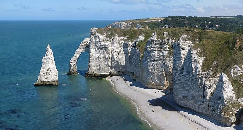 The Étretat Cliffs rise dramatically above France’s Normandy coast. Their white chalk walls, natural arches, and offshore rock needle create one of Europe’s most recognizable coastal landscapes.
Geological significance:
The cliffs are mainly composed of Cretaceous chalk, a soft limestone formed from the accumulated remains of microscopic marine organisms. Their distinctive horizontal layers are clearly visible along the coastline.
How it formed:
The chalk was deposited beneath an ancient sea millions of years ago. Over time, geological uplift exposed these layers along the Normandy coast.
Waves then began cutting into weaknesses in the cliffs. Continuous erosion created caves and arches, while sections of rock were eventually isolated as sea stacks. The famous Aiguille, or Needle, is one of the best-known results of this process.
Where is it?
Étretat is on the Alabaster Coast of Normandy, in northern France. The cliffs surround the small coastal town of Étretat, about 30 kilometers northeast of Le Havre.
Best time to visit:
Late spring through early autumn offers pleasant conditions for coastal walks. Visit early in the morning or later in the afternoon for softer light and fewer crowds.
What to see nearby:
The Porte d’Aval arch and Aiguille are the most famous formations. Walk toward the Porte d’Amont viewpoint for another perspective, or explore Étretat’s historic town center.
Visitor tips:
Stay on marked paths and keep away from unstable cliff edges. Check tide times before exploring beaches or areas below the cliffs, as access can change with the tide.
Étretat shows how slowly eroding chalk can produce dramatic coastal scenery. Its arches, cliffs, and sea stacks are still being reshaped by the sea today.
7. Durdle Door, England
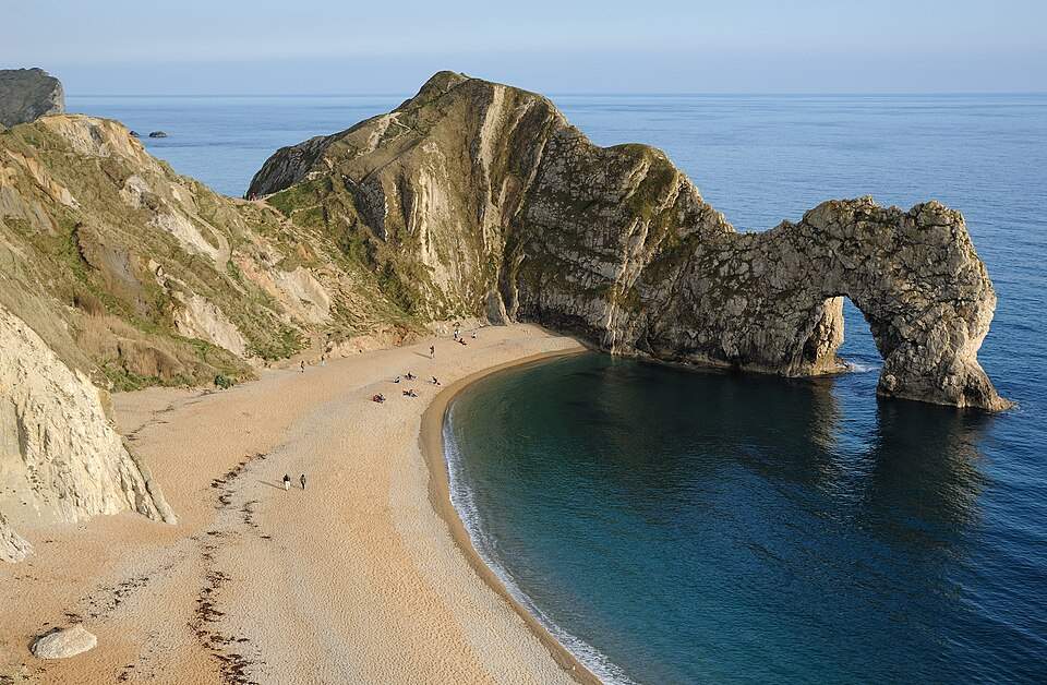 Durdle Door is one of England’s most famous natural coastal arches. The huge limestone opening stands on the Jurassic Coast in Dorset, where the sea has shaped the shoreline over millions of years.
Geological significance:
Durdle Door formed in Portland limestone, a hard sedimentary rock deposited in a shallow tropical sea during the Jurassic Period. The surrounding coastline contains several different rock types and preserves a remarkable record of geological history.
How it formed:
The sea gradually exploited a natural weakness in the limestone. Continued erosion enlarged the opening until it became the impressive arch visible today.
The surrounding cliffs are still exposed to coastal erosion. Over long periods, the arch will continue to change as waves attack the rock.
Where is it?
Durdle Door lies near Lulworth in Dorset, southern England. It is part of the Jurassic Coast, a World Heritage Site stretching along the Dorset and Devon coastline.
Best time to visit:
Late spring and summer offer longer daylight for coastal walks. Early mornings are usually quieter, while clear weather gives the best views from the surrounding cliffs.
What to see nearby:
Lulworth Cove is the obvious companion attraction. The nearby coastline also includes Stair Hole, Man O’War Beach, and several sections of the South West Coast Path.
Visitor tips:
The path to the beach involves a steep descent and climb. Wear suitable footwear and check conditions before walking. Avoid getting too close to cliff edges, and pay attention to tide conditions on the beach.
Durdle Door is a striking example of coastal erosion at work. Its famous arch also forms part of a much larger geological story preserved along England’s Jurassic Coast.
8. Jurassic Coast, England
The Jurassic Coast is one of the world’s most remarkable geological coastlines. Stretching along the southern coast of England, it exposes around 185 million years of Earth’s history in its cliffs, beaches, fossils, and rock formations.
Geological significance:
The coastline records three major geological periods: the Triassic, Jurassic, and Cretaceous. Its exposed rocks contain fossils and evidence of ancient environments that changed dramatically over geological time.
How it formed:
Layers of sediment accumulated in changing seas, lagoons, rivers, and coastal environments. Over millions of years, these sediments hardened into rocks such as limestone, sandstone, and mudstone.
Tectonic forces later tilted and uplifted the layers. The sea then eroded the coastline, exposing the geological record and creating cliffs, arches, coves, and beaches.
Where is it?
The Jurassic Coast extends for about 155 kilometers along Dorset and East Devon in southern England. Major stops include Lyme Regis, Charmouth, Lulworth Cove, Durdle Door, and Weymouth.
Best time to visit:
Late spring through early autumn is ideal for coastal walks and fossil hunting. Spring and autumn can offer quieter trails and comfortable walking conditions.
What to see nearby:
Lulworth Cove and Durdle Door are among the most famous sights. Lyme Regis and Charmouth are especially popular for fossil discoveries along the coast.
Visitor tips:
Always check tide times before exploring beaches or fossil-hunting areas. Stay away from unstable cliff faces and follow local fossil-collecting rules. Never hammer or damage the cliffs.
The Jurassic Coast is more than a scenic destination. It is an enormous geological record exposed along the shoreline, allowing visitors to explore Earth’s changing environments through rocks and fossils.
9. White Cliffs of Dover, England
The White Cliffs of Dover form one of England’s most recognizable coastal landscapes. Their bright white walls rise above the English Channel, creating a dramatic natural landmark facing continental Europe.
Geological significance:
The cliffs are made mainly of chalk, a soft, fine-grained limestone formed from the microscopic remains of marine organisms. Their bright color comes from the high proportion of calcium carbonate in the rock.
How it formed:
During the Cretaceous Period, much of this region lay beneath a warm, shallow sea. Tiny marine organisms lived in its waters and left behind microscopic calcium-rich remains when they died.
Over millions of years, these remains accumulated on the seabed and became chalk. Later geological movements raised the deposits above sea level, while waves and weather gradually shaped the exposed coastline.
Where is it?
The cliffs are located around Dover in Kent, southeastern England. They face the English Channel and sit close to the shortest sea crossing between England and France.
Best time to visit:
Late spring through early autumn offers the most comfortable conditions for walking the cliff-top trails. Clear days also provide the best views across the English Channel.
What to see nearby:
Dover Castle sits above the coastline and provides another major attraction. The nearby South Foreland Lighthouse and coastal walking routes offer different perspectives of the cliffs.
Visitor tips:
Stay well back from the cliff edge because sections can collapse without warning. Keep to marked paths and avoid walking too close to unstable edges, particularly after wet or stormy weather.
The White Cliffs of Dover show how tiny marine organisms can leave behind a massive geological legacy. Their chalk layers also help reveal the environmental conditions of an ancient Cretaceous sea.
10. Benagil Cave, Portugal
Benagil Cave is one of Portugal’s most famous coastal formations. The vast sea cave on the Algarve coast is known for its golden limestone walls, sandy floor, and large opening in the roof.
Geological significance:
The cave is part of the Algarve’s limestone coastline, where marine erosion has carved cliffs, caves, arches, and rock platforms. Its rounded chambers show how persistent wave action can reshape relatively soft sedimentary rock.
How it formed:
The Algarve’s limestone formed from sediments deposited in ancient marine environments. Over time, the rock was exposed and shaped by natural weathering and erosion.
Waves repeatedly attacked cracks and weaker layers along the coast. Gradual erosion enlarged these openings into caves and arches. At Benagil, erosion also created an opening in the cave roof, allowing sunlight to illuminate the interior.
Where is it?
Benagil Cave lies near the small fishing village of Benagil in the Algarve, between the coastal towns of Carvoeiro and Albufeira. It is part of a coastline known for dramatic limestone scenery.
Best time to visit:
Late spring through early autumn generally offers the best conditions for coastal excursions. Morning visits can provide calmer conditions and better light inside the cave.
What to see nearby:
The surrounding Algarve coast is filled with similar formations. Praia da Marinha, Algar Seco, and the Seven Hanging Valleys Trail are excellent additions to a coastal itinerary.
Visitor tips:
Sea conditions determine how the cave can be accessed. Boat trips are the most common option, while kayaking and other water activities may be available depending on local conditions and regulations. Never swim into the cave unless local authorities or operators confirm that conditions are safe.
Benagil Cave shows how patiently the sea can reshape a rocky coastline. Its dramatic chamber is one of the Algarve’s clearest examples of wave-carved coastal limestone.
11. Pancake Rocks, New Zealand
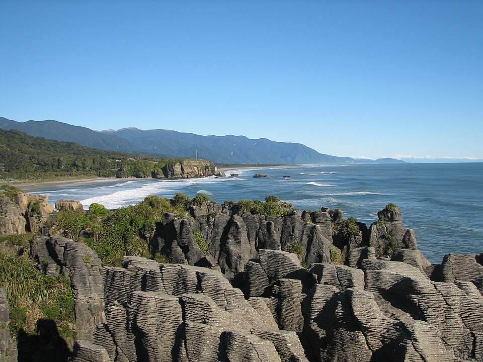
Pancake Rocks are a spectacular group of limestone formations on New Zealand’s South Island. Their unusual layers resemble stacks of pancakes, while powerful waves crash through nearby blowholes and coastal channels.
Geological significance:
The rocks consist mainly of limestone formed from marine sediments. Their distinctive layers developed through geological processes that affected the rock at different rates.
How it formed:
The limestone accumulated on the seabed millions of years ago. Over time, layers of marine material became compressed and cemented into rock.
Later, uplift exposed the limestone along the coast. Rain, wind, and powerful waves gradually exploited weaknesses between the layers. The result was the distinctive stacked appearance, along with caves, channels, cliffs, and blowholes.
The erosion continues today. During strong swells, seawater can surge through underground passages and erupt through the famous blowholes.
Where is it?
Pancake Rocks are at Punakaiki on New Zealand’s West Coast, between Westport and Greymouth. The formations are part of Paparoa National Park.
Best time to visit:
 The site can be visited throughout the year. For the most dramatic blowhole displays, plan your visit around high tide, while also checking local conditions and safety information.
What to see nearby:
Paparoa National Park offers rainforest, limestone landscapes, caves, and coastal walking trails. The Paparoa Track provides a longer way to experience the area’s diverse landscapes.
Visitor tips:
Follow the designated Pancake Rocks and Blowholes Walk. Stay behind barriers and keep away from exposed edges, especially when large swells are running.
Pancake Rocks show how layered limestone can develop extraordinary coastal shapes. Add powerful Pacific waves and underground channels, and the result becomes one of New Zealand’s most fascinating geological attractions.
12. Moeraki Boulders, New Zealand
Moeraki Boulders look almost too perfectly round to be natural. These huge stone spheres lie scattered along Koekohe Beach on New Zealand’s South Island, creating one of the country’s most unusual coastal landscapes.
Geological significance:
The boulders are concretions, not ordinary beach rocks. They formed inside layers of ancient marine mudstone, where minerals gradually accumulated around a central core.
Some boulders measure more than two meters across. Their unusually smooth, rounded shapes make them especially striking when exposed on the beach.
How it formed:
The concretions began forming within marine sediments roughly 60 million years ago. Dissolved minerals slowly gathered around small pieces of shell, bone, or other material.
Over a very long period, the minerals cemented the surrounding sediment into hard, spherical masses. Later, coastal erosion removed the softer mudstone and exposed the boulders.
Some still remain partly embedded in the surrounding rock. Others have been released and now rest on the beach.
Where is it?
Moeraki Boulders are on Koekohe Beach near Moeraki, on the Otago coast of New Zealand’s South Island. The site lies between the cities of Oamaru and Dunedin.
Best time to visit:
Visit around low tide when more of the beach and boulders are exposed. Early morning and late afternoon offer softer light and fewer visitors.
What to see nearby:
The nearby fishing village of Moeraki is known for its coastal scenery and seafood. Katiki Point is another worthwhile stop, with opportunities to see seabirds and marine wildlife.
Visitor tips:
Check tide times before visiting because the boulders look very different as the water rises. Avoid climbing on fragile formations, and treat the beach as a natural geological site rather than a playground.
Moeraki Boulders demonstrate that coastal geological wonders do not always need towering cliffs or volcanic activity. Sometimes, millions of years of mineral growth and erosion can produce almost perfect natural spheres.
13. Bombo Headland, Australia
Bombo Headland is one of Australia’s most unusual coastal geological landscapes. Its tall basalt columns rise beside the Pacific Ocean near Kiama, creating a dramatic meeting point between volcanic rock and the sea.
Geological significance:
The headland contains striking columnar basalt, formed from ancient volcanic lava. The regular columns are especially impressive because they stand exposed along the shoreline.
How it formed:
During the Late Permian, roughly 250 million years ago, volcanic lava cooled and hardened in this area. As the lava contracted, it developed a network of cracks.
Those cracks extended through the cooling rock and produced the vertical columns visible today. Later erosion removed surrounding material and exposed the basalt more clearly.
The Pacific continues to attack the exposed rock. Over time, waves and weathering will continue to alter the headland.
Where is it?
Bombo Headland lies near Kiama on the New South Wales South Coast, about 120 kilometers south of Sydney. It is easily combined with other attractions along the Grand Pacific Drive.
Best time to visit:
Spring and autumn are comfortable seasons for walking around the headland. Early morning and late afternoon can provide excellent light for photographing the basalt columns.
What to see nearby:
The Kiama Blowhole is only a short distance away and makes an excellent companion stop. Cathedral Rocks and the Kiama coastline offer more examples of dramatic coastal geology.
Visitor tips:
Stay on established paths and keep away from exposed cliff edges. Ocean conditions can change quickly, so avoid approaching the water on the rock platforms during rough weather.
Bombo Headland offers a fascinating contrast to Australia’s better-known limestone coastlines. Its dark volcanic columns provide a clear example of how ancient lava can become a spectacular coastal landscape.
14. Kiama Blowhole, Australia
The Kiama Blowhole is one of Australia’s most spectacular examples of wave-driven coastal erosion. When ocean swells enter its underground passage, seawater can shoot high into the air above the rocky shoreline.
Geological significance:
The blowhole formed in volcanic rock along the Kiama coast. Its chamber and narrow passage demonstrate how waves can exploit cracks and weaknesses within coastal rock.
Unlike a sea cave that simply opens into the ocean, a blowhole channels seawater through a confined passage. Pressure from incoming waves can then force water upward through an opening in the rock.
How it formed:
Ancient volcanic activity produced the rock along this part of the New South Wales coast. Over time, waves attacked fractures within the headland.
Continued erosion enlarged an underground cavity and created a narrow connection with the ocean. Repeated wave action eventually produced the vertical opening that allows seawater to erupt above the surface.
The process continues today, although the strength of the spray depends heavily on ocean conditions.
Where is it?
The Kiama Blowhole is in Kiama, New South Wales, about 120 kilometers south of Sydney. It is one of the easiest geological attractions to visit along the South Coast.
Best time to visit:
The blowhole can be visited throughout the year. Strong swells can produce spectacular displays, but they also create more dangerous conditions. Always check local warnings before approaching the viewing area.
What to see nearby:
Bombo Headland is close by and features impressive basalt columns. Cathedral Rocks and the surrounding Kiama coastline offer additional examples of volcanic coastal geology.
Visitor tips:
Never stand on exposed rocks to get closer to the spray. Large waves can arrive unexpectedly and sweep people into the ocean. Use designated viewing areas and follow local safety signs.
The Kiama Blowhole is a reminder that coastal geology is still evolving. Every powerful wave that enters the rock contributes to the long process of erosion that continues to reshape the headland.
15. Varkala Cliffs, India
Varkala Cliffs rise above the Arabian Sea along Kerala’s southwestern coast. Their reddish-brown layers form a striking backdrop to Varkala Beach and reveal a geological history far older than the modern coastline.
Geological significance:
The cliffs expose the Warkalli Formation, a sequence of sedimentary rocks associated with the Mio-Pliocene period. Their layers contain sand, silt, and other sediments deposited in changing environments over geological time.
The cliffs are also recognized for their geological and geomorphological importance. UNESCO has included Varkala in India’s Tentative List of World Heritage Sites.
How it formed:
The sediments that became Varkala’s cliffs accumulated over a long period. Geological processes later lifted and exposed these layers along the coast.
Once exposed, the cliffs were gradually shaped by weathering and erosion. Rain and groundwater also affect the softer sedimentary layers, while the sea continues to influence the coastline below.
Where is it?
Varkala is in Thiruvananthapuram district, Kerala, overlooking the Arabian Sea. The cliffs extend along the coast near the popular Varkala Beach.
Best time to visit:
October to March is generally the most comfortable period for exploring Varkala. The weather is usually drier and better suited to coastal walks and sightseeing.
What to see nearby:
Varkala Beach sits directly below the cliffs and is the area’s main attraction. Janardana Swamy Temple, Kappil Beach, and Kappil Lake are also worth adding to a Kerala itinerary.
Visitor tips:
Stay away from unstable cliff edges and avoid walking too close to eroded sections. The beach can also have strong waves, so follow local swimming and safety advice.
Varkala offers a different kind of coastal geological wonder. Instead of dramatic basalt columns or offshore stacks, its layered sedimentary cliffs reveal the geological story beneath one of Kerala’s most famous beaches.
16. St. Mary’s Islands, India
St. Mary’s Islands are a small group of islands off the coast of Karnataka, known for their striking hexagonal basalt columns. Rising along the Arabian Sea, these dark rock formations create one of India’s most unusual coastal landscapes.
Geological significance:
The islands are famous for their columnar basalt, a volcanic rock that formed distinctive polygonal columns as it cooled. The columns are particularly unusual because of their regular shapes and their exposure along the shoreline.
The geological significance of the islands has also been recognized through India’s heritage and geological conservation efforts. Their columnar igneous formations are an important example of ancient volcanic activity. Current UNESCO documentation highlights rhyolitic lava in its comparison and justification, while its site description also refers to basaltic origins.
How it formed:
The columnar lava formed when molten rock cooled and contracted during the Late Cretaceous, roughly 85–88 million years ago. As the rock shrank, fractures developed through the cooling lava.
These cooling fractures produced the characteristic column-like shapes. Subsequent weathering and coastal erosion exposed the columns and helped create the rugged shoreline seen today.
Where is it?
St. Mary’s Islands lie in the Arabian Sea off the coast of Malpe, Karnataka. They are only a short boat journey from Malpe Beach, near the coastal city of Udupi.
Best time to visit:
The best time is generally October to May, when sea conditions are more suitable for visiting the islands. Boat services can depend on weather and local operating conditions.
What to see:
The columnar basalt formations are the main attraction. Malpe Beach, Udupi, and nearby coastal areas can easily be included in the same trip.
Visitor tips:
Follow local island-access rules and avoid climbing or damaging the basalt formations. Boat services may stop during rough seas, so check conditions before travelling.
St. Mary’s Islands show how volcanic activity can create remarkably geometric landscapes. Their basalt columns make them one of India’s most distinctive coastal geological wonders.
17. Yehliu Geopark, Taiwan
Yehliu Geopark is a remarkable coastal landscape on Taiwan’s northern tip. Its narrow peninsula is filled with strange rock shapes, sea cliffs, caves, and wave-cut platforms.
Among its most famous formations is the Queen’s Head, a mushroom-shaped rock created by long-term erosion and weathering. Other formations resemble candles, ice cream, and giant mushrooms.
Geological significance:
Yehliu’s rocks are mainly sedimentary. Their unusual shapes result from the different rates at which layers of rock resist erosion.
The peninsula is also an excellent example of coastal erosion and weathering working together. Wind, rain, and waves continue to modify the exposed rock.
How it formed:
The sedimentary rocks developed from deposits that accumulated millions of years ago. Geological forces later uplifted the layers above the sea.
Once exposed, the rocks faced constant weathering and wave action. Softer sections eroded faster, while harder areas remained standing. This uneven erosion created the peninsula’s remarkable rock formations.
Where is it?
Yehliu Geopark is in New Taipei City, on Taiwan’s northern coast. It lies on a narrow peninsula extending into the East China Sea, about 90 minutes from central Taipei by road.
Best time to visit:
The cooler months from October to April can be comfortable for walking around the exposed park. Early morning is a good choice for softer light and fewer visitors.
What to see:
The Queen’s Head is the park’s most famous formation. Candlestick Rocks, Fairy Shoe, Ginger Rocks, and the wave-cut platforms provide many other unusual shapes to explore.
Visitor tips:
Stay on marked paths and respect barriers around fragile formations. The coastal rocks can be slippery, and exposed areas can become uncomfortable during hot or windy weather.
Yehliu Geopark shows how ordinary geological processes can create extraordinary shapes. Over time, waves and weather have transformed layers of sedimentary rock into a natural outdoor sculpture gallery.
18. Los Gigantes, Tenerife, Spain
Los Gigantes rises dramatically from the Atlantic Ocean on the western coast of Tenerife. The near-vertical cliffs tower above the sea, forming one of the Canary Islands’ most impressive volcanic landscapes.
Geological significance:
The cliffs are part of Tenerife’s volcanic landscape, built from successive eruptions and lava flows over millions of years. Different layers of volcanic rock can be seen across the towering cliff faces.
Their height and steep profile also show the effects of long-term erosion. The Atlantic has gradually cut into the volcanic coastline, helping create the dramatic walls seen today.
How it formed:
Tenerife was built by volcanic activity over a very long period. Repeated eruptions deposited layers of lava and other volcanic material across the island.
Later erosion attacked the exposed western coastline. Waves, weathering, and rockfalls gradually removed weaker material, leaving sections of the ancient volcanic landscape standing as enormous cliffs.
Where is it?
Los Gigantes is on the western coast of Tenerife, in the Canary Islands of Spain. The cliffs are best viewed from the coastal town of Puerto de Santiago or from the sea.
Best time to visit:
Tenerife has a mild climate throughout the year. Spring and autumn are particularly pleasant for boat trips, coastal walks, and sightseeing.
What to see:
A boat trip along the cliffs offers the most impressive perspective. The waters around Los Gigantes can also provide opportunities to see dolphins and other marine life.
Visitor tips:
Wear sun protection and carry water during coastal excursions. If taking a boat trip, check sea conditions and choose an operator that follows local safety requirements.
Los Gigantes demonstrates the enormous scale that volcanic activity can create. Its towering cliffs are a powerful reminder that Tenerife’s coastline is still shaped by erosion long after its major volcanic eruptions ended.
19. Old Man of Hoy, Scotland
The Old Man of Hoy is a towering sea stack rising from the Atlantic beside Hoy in Scotland’s Orkney Islands. Its isolated shape and sheer red cliffs make it one of Britain’s most famous coastal rock formations.
Geological significance:
The stack is made mainly of Old Red Sandstone, a rock formed from sediments deposited hundreds of millions of years ago. Its steep walls expose layers of ancient sandstone shaped by long-term coastal erosion.
How it formed:
The sandstone cliffs were gradually weakened by weathering and powerful Atlantic waves. Caves and cracks developed along natural weaknesses in the rock.
Continued erosion eventually separated a section of the cliff from the mainland. The remaining rock became the isolated sea stack we see today.
The stack is still being eroded. Its shape has changed significantly over historical time, and further collapse is expected eventually.
Where is it?
The Old Man of Hoy stands on the western coast of Hoy, part of the Orkney Islands in northern Scotland. It faces the open Atlantic and is best viewed from the surrounding coastal paths or from the sea.
Best time to visit:
Late spring and summer generally offer the best conditions for hiking and sightseeing. Weather can change rapidly, so always check the forecast before setting out.
What to see nearby:
Hoy offers much more than the famous stack. The Hoy Hills, Rackwick Bay, and St John’s Head provide spectacular scenery and additional opportunities to explore the island.
Visitor tips:
Reaching the best viewpoints involves a demanding coastal walk. Wear sturdy footwear and allow plenty of time. Keep away from cliff edges, particularly during strong winds or poor visibility.
The Old Man of Hoy is a striking example of a sea stack created by coastal erosion. Its exposed sandstone also gives visitors a glimpse into a geological landscape hundreds of millions of years old.
20. Cathedral Rocks, Australia
Cathedral Rocks is a striking coastal formation near Kiama on Australia’s New South Wales South Coast. Jagged volcanic rocks rise from the shoreline, creating a rugged landscape shaped by ancient lava and powerful waves.
Geological significance:
The formations are part of Kiama’s volcanic coastline, where Bombo Latite, a volcanic rock, has been exposed and shaped by erosion. The dark rock contrasts sharply with the Pacific Ocean, making the site especially dramatic during rough seas.
How it formed:
Ancient volcanic activity produced thick volcanic flows across this part of the coast. As the lava cooled, it hardened into durable volcanic rock.
Over millions of years, waves attacked cracks and weaker sections. Weathering and erosion gradually removed softer material, leaving the rugged rock platforms and jagged formations visible today.
Where is it?
Cathedral Rocks is near Kiama on the New South Wales South Coast, about 120 kilometers south of Sydney. The formation lies close to Bombo Headland and the Kiama Blowhole.
Best time to visit:
The site can be visited throughout the year. Spring and autumn offer comfortable conditions for exploring the coast, while early morning and late afternoon provide good light for photography.
What to see:
The rock formations themselves are the main attraction. Nearby Bombo Headland and Kiama Blowhole make it easy to explore several examples of coastal volcanic geology in one trip.
Visitor tips:
Stay on safe viewing areas and avoid exposed rock platforms during large swells. Waves can reach much farther inland than expected, especially during storms or high surf.
Cathedral Rocks shows how ancient volcanic landscapes can be transformed by the ocean. Basalt, weathering, and wave erosion have combined to create a rugged coastline unlike the softer cliffs found elsewhere in Australia.
21. Algarve Coastal Rock Formations, Portugal
The Algarve is famous for a coastline shaped by limestone, wind, and waves. Along southern Portugal, golden cliffs rise above the Atlantic, with arches, sea caves, pillars, and narrow rock formations scattered between sandy beaches.
Geological significance:
Much of the Algarve’s dramatic coastline consists of Mesozoic limestone and related sedimentary rocks. These rocks contain layers formed in ancient marine environments.
Their exposed surfaces show how coastal erosion can create highly varied landscapes. Harder rock can remain as pillars and arches, while weaker sections gradually disappear.
How it formed:
The region’s limestone developed from sediments deposited in ancient seas. Geological uplift later exposed the rocks to weathering and coastal erosion.
Waves began attacking cracks, joints, and weaker layers along the shoreline. Over time, this process enlarged caves, carved arches, and separated sections of the cliffs into isolated formations.
The process continues today. Every storm and wave contributes to the gradual reshaping of this coastline.
Where is it?
These formations occur along much of the Algarve coast in southern Portugal. Particularly impressive scenery can be found around Lagos, Carvoeiro, Lagoa, and Albufeira.
Best time to visit:
April to October is ideal for exploring the coast, with warmer weather and generally better conditions for boat trips. Spring and early autumn can offer a quieter experience.
What to see:
The coastline around Ponta da Piedade, Praia da Marinha, Benagil, and Algar Seco offers some of the region’s most impressive rock formations. Coastal walking trails and boat excursions provide different perspectives.
Visitor tips:
Check tide and sea conditions before exploring caves or beaches beneath the cliffs. For boat trips, choose a licensed operator and follow local safety instructions.
The Algarve shows how sedimentary rock can become an extraordinary coastal landscape. Its arches, caves, cliffs, and rock pillars are the result of millions of years of geological change along the Atlantic shore.
22. Praia da Marinha, Portugal
Praia da Marinha is one of Portugal’s most striking coastal landscapes. Golden limestone cliffs surround a small beach, with natural arches, rock pillars, and clear Atlantic water creating a dramatic setting.
Geological significance:
The beach lies along the Algarve’s limestone coastline, where layers of sedimentary rock have been exposed and shaped by erosion. The cliffs contain natural cracks and joints that have helped the sea carve distinctive formations.
How it formed:
The limestone formed from sediments deposited in ancient marine environments. Over time, geological uplift brought these rocks closer to the surface.
Rain and weathering weakened the exposed limestone. Waves then attacked cracks along the shoreline, gradually enlarging them into caves, arches, and isolated rock pillars.
The famous double-arch formation offshore is a particularly clear example of this ongoing coastal erosion.
Where is it?
Praia da Marinha is near Carvoeiro and Lagoa in the Algarve, southern Portugal. It lies between several other notable coastal formations and is accessible by road and walking trails.
Best time to visit:
Late spring and early autumn offer a good balance of pleasant weather and fewer visitors. Arriving early also makes it easier to enjoy the viewpoints before the beach becomes busy.
What to see:
The natural arches and offshore stacks are the main geological highlights. The nearby Seven Hanging Valleys Trail offers excellent views of the surrounding limestone coast.
Visitor tips:
The cliffs can be unstable, so stay on marked paths and keep away from the edges. If swimming or exploring the shoreline, check tide and sea conditions first.
Praia da Marinha shows how limestone coastlines can develop intricate shapes over time. Its arches, cliffs, and offshore rocks make it a strong example of wave-shaped coastal geology.
23. Great Ocean Road Coastal Formations, Australia
The Great Ocean Road is more than one of Australia’s most scenic drives. Its western section follows the Shipwreck Coast, where limestone cliffs, sea stacks, arches, caves, and offshore islands reveal the powerful effects of coastal erosion.
Geological significance:
The Shipwreck Coast contains extensive limestone formations shaped by the Southern Ocean. The coastline includes some of Australia’s best-known erosional landforms, including the Twelve Apostles and London Bridge.
The exposed cliffs also contain evidence of ancient marine environments. Their layers help explain how the region’s landscape developed over geological time.
How it formed:
Marine sediments accumulated and eventually became limestone. Geological movements later exposed these rocks along the coast.
Powerful waves then attacked cracks and weaker sections of the cliffs. Caves developed first, followed by arches. When arches collapsed, isolated sea stacks remained offshore.
Erosion continues today, constantly changing the coastline.
Where is it?
The Great Ocean Road runs along Victoria’s southern coast, west of Melbourne. The most dramatic geological formations are concentrated around the Port Campbell National Park and the wider Shipwreck Coast.
Best time to visit:
Spring and autumn offer comfortable conditions for a road trip. Summer provides longer daylight but can be considerably busier. Early mornings are ideal for quieter viewpoints.
What to see:
The Twelve Apostles, Loch Ard Gorge, London Bridge, The Grotto, and Bay of Islands are among the standout geological attractions. Together, they make this one of Australia’s best coastal geology road trips.
Visitor tips:
Allow more time than you think you need. The geological attractions are spread along the coast, and several involve short walks from designated parking areas. Stay behind barriers and away from unstable cliff edges.
The Great Ocean Road offers a rare chance to experience coastal geology as a journey. Every viewpoint reveals another stage in the long process of erosion that continues to reshape Victoria’s coastline.
24. Cape Perpetua, Oregon, USA
Cape Perpetua is a dramatic headland on Oregon’s Pacific coast. Dense forest meets rugged basalt cliffs, while powerful waves have carved caves, channels, and rocky platforms along the shoreline.
Geological significance:
The headland is built largely from basaltic volcanic rocks associated with ancient lava flows. Long-term uplift and erosion have exposed these rocks along the coast.
The area also shows how waves can exploit fractures in volcanic rock. Over time, this process has produced sea caves, rock platforms, and other striking coastal features.
How it formed:
Ancient volcanic activity produced layers of basalt across this part of Oregon. Later geological uplift raised the rocks above sea level.
Once exposed, the coastline faced constant attack from Pacific waves. Water entered cracks and weaknesses in the basalt, gradually enlarging them into caves and channels. Continued erosion shaped the rugged shoreline seen today.
Where is it?
Cape Perpetua is on the central Oregon coast, within the Siuslaw National Forest. It lies about 3 miles south of Yachats and roughly 135 miles southwest of Portland.
Best time to visit:
Summer offers the driest weather and easiest conditions for exploring the viewpoints and trails. Spring and autumn can be quieter, but coastal weather changes quickly.
What to see:
The Cape Perpetua Scenic Area, Thor’s Well, Spouting Horn, and Devil’s Churn are the major attractions. The Cape Perpetua Overlook also provides sweeping views of the Pacific coastline.
Visitor tips:
Be extremely cautious around the shoreline. Features such as Thor’s Well can appear calm but become dangerous during large swells. Keep a safe distance from the water and stay on designated trails and viewpoints.
Cape Perpetua demonstrates how volcanic rock can be transformed by the ocean. Basalt, tectonic forces, and relentless wave erosion have combined to create one of Oregon’s most dramatic coastal landscapes.
25. Big Sur Coast, California, USA
The Big Sur Coast is one of California’s most dramatic geological landscapes. Rugged mountains rise directly from the Pacific, while steep cliffs, rocky coves, and offshore formations line the shoreline.
Geological significance:
Big Sur lies within the complex tectonic setting of the San Andreas Fault system. Uplift, faulting, fractured rocks, landslides, and wave erosion all shape the coast. The region’s rocks have been uplifted, fractured, and reshaped by powerful geological forces.
The coastline also experiences frequent landslides. Steep slopes, fractured rock, heavy rainfall, and wave erosion continually reshape the landscape.
How it formed:
Tectonic activity played a major role in creating Big Sur’s rugged terrain. Movement along nearby faults helped uplift and deform the rocks over millions of years.
The Pacific Ocean then began eroding the exposed coastline. Waves cut into cliffs and rocky headlands, while gravity and weathering caused sections of the steep terrain to collapse.
This combination of tectonic activity and erosion continues to shape Big Sur today.
Where is it?
Big Sur stretches along California’s central Pacific coast, between Carmel-by-the-Sea and San Simeon. Highway 1 follows much of the coastline and provides access to numerous viewpoints and natural areas.
Best time to visit:
Spring and autumn offer pleasant conditions for exploring the coast. Summer is popular but can be busy, while winter can bring heavy rain, landslides, and temporary road closures.
What to see:
Bixby Creek Bridge, McWay Falls, Point Sur, and Pfeiffer Beach are among the best-known sights. Several coastal viewpoints also reveal the region’s steep cliffs and rugged geology.
Visitor tips:
Check road conditions before travelling, especially after heavy rain. Stay on designated trails and viewpoints because steep cliffs and unstable ground can make some areas dangerous.
Big Sur brings our journey to a coastline where geology is still very active. Tectonic forces continue to shape the land, while waves, weather, and landslides constantly remodel its spectacular Pacific shoreline.
Coastal Geological Wonders by Formation Type
Coastal geological wonders come in many forms. Some were created by volcanic activity, while others were carved slowly by waves, wind, weathering, and tectonic forces.
Understanding these formation types makes the landscapes easier to appreciate. A towering sea stack, for example, may be the final stage of erosion that began with a coastal cliff.
The world’s most remarkable examples generally fall into several broad geological categories.
Basalt Columns and Volcanic Coastal Formations
Volcanic coastlines can produce some of the world’s most unusual rock shapes. When thick lava cools, it can contract and develop distinctive cracks.
Over time, these cracks may form polygonal columns. Waves can then expose and reshape the volcanic rock along the coast.
Dramatic Coastal Cliffs
Coastal cliffs form where erosion removes rock faster than the land can resist it. Their appearance depends heavily on the type and structure of the underlying rock.
Some cliffs expose ancient sedimentary layers. Others consist of volcanic rocks shaped by uplift, faulting, and erosion.
Sea Stacks and Rock Pillars
Sea stacks are isolated columns of rock standing offshore. They often begin as sections of a coastal cliff weakened by cracks and erosion.
Waves can first create caves and arches. Continued erosion eventually causes the arches to collapse, leaving isolated stacks behind.
Sea Caves and Natural Arches
Sea caves usually develop when waves attack weaknesses in coastal rock. Continued erosion can enlarge a cave until it breaks through a headland and creates an arch.
These formations are especially common along fractured limestone and other sedimentary coastlines.
Wave-Carved Coastal Formations
Waves are among the most powerful forces shaping rocky shorelines. They can carve platforms, channels, blowholes, caves, and unusual rock shapes.
The effect becomes especially dramatic where rocks contain natural cracks or layers with different levels of resistance.
Ancient Sedimentary and Fossil Coastlines
Sedimentary coastlines can preserve evidence of ancient seas, rivers, marine organisms, and changing environments. Their exposed layers often provide a visible record of geological history.
Fossil-rich cliffs and unusual sedimentary formations can therefore be both scenic attractions and important scientific sites.
These formation types show why coastal geology is so diverse. The same forces that slowly wear down a coastline can also create some of the world’s most extraordinary natural landmarks.
Basalt Columns and Volcanic Coastal Formations
Some of the world’s most striking coastal formations began as molten lava. When thick basaltic lava cools and contracts, it can develop a network of fractures that produces tall, geometric columns.
These columns can have five, six, or more sides. Their shapes are not carved by humans. They result from the natural cooling and contraction of volcanic rock.
Coastal erosion then exposes these formations. Waves, weathering, and rockfalls can gradually reshape the volcanic landscape.
Several destinations in this guide show this process particularly well:
- Giant’s Causeway, Northern Ireland: Thousands of basalt columns form its famous stepped shoreline. The formation developed from ancient volcanic lava flows.
- Fingal’s Cave, Scotland: Hexagonal basalt columns surround this remarkable sea cave on Staffa. Waves later carved the cave through the volcanic rock.
- Mary’s Islands, India: These islands are known for their distinctive columnar basalt formations along the Arabian Sea.
- Reynisdrangar, Iceland: Dark basalt sea stacks rise offshore from Reynisfjara, surrounded by Iceland’s dramatic volcanic coastline.
Although these formations share a volcanic origin, no two coastlines look exactly alike. Cooling patterns, rock structure, erosion, and ocean conditions give each site its own character.
Together, they show how ancient volcanic activity can create coastal landscapes that remain spectacular millions of years later.
Dramatic Coastal Cliffs
Coastal cliffs are among the most powerful landscapes shaped by the meeting of land and sea. They form when waves and weather gradually remove material from an exposed coastline.
The geology underneath the cliffs makes a major difference. Layered sedimentary rocks can create visible bands, while volcanic rocks often produce darker and more rugged walls.
Four destinations in this guide show this variety particularly well:
- Cliffs of Moher, Ireland: Layers of sandstone, siltstone, and shale rise dramatically above the Atlantic. Their exposed rock records more than 300 million years of geological history.
- Varkala Cliffs, India: These reddish-brown sedimentary cliffs rise above the Arabian Sea. Their exposed layers belong to the Mio-Pliocene Warkalli Formation.
- White Cliffs of Dover, England: These bright white chalk cliffs formed from the remains of microscopic marine organisms deposited in an ancient sea.
- Los Gigantes, Tenerife, Spain: Towering volcanic cliffs dominate Tenerife’s western coast. Their steep walls reflect the island’s volcanic origins and long-term erosion.
Cliffs are not static structures. Waves continue to attack their bases, while rain, wind, weathering, and gravity weaken the rock above.
Over time, sections can crack, collapse, and retreat inland. Every cliff therefore represents a landscape still being shaped by natural forces.
Sea Stacks and Rock Pillars
Sea stacks are isolated columns of rock standing beside or offshore from a coastline. They often form when waves gradually erode a headland, first creating cracks, caves, and arches.
If erosion continues, an arch can eventually collapse. The remaining section of resistant rock becomes a sea stack or rock pillar.
The three destinations below show different examples of this process:
- Twelve Apostles, Australia: These limestone stacks stand along Victoria’s Shipwreck Coast. They are remnants of the coastal cliffs, separated as waves enlarged cracks, caves, and arches.
- Old Man of Hoy, Scotland: This towering red sandstone stack rises from the coast of Hoy in the Orkney Islands. Long-term erosion separated it from the surrounding cliffs.
- Cathedral Rocks, Australia: These rugged formations near Kiama are made from volcanic rock. Wave action and weathering have shaped the exposed basalt into distinctive coastal forms.
Sea stacks eventually face the same forces that created them. Waves continue to weaken their bases, while weathering and gravity affect the rock above.
Their changing shapes are a reminder that coastal geology is an ongoing process, not a finished landscape.
Sea Caves and Coastal Arches
Sea caves and coastal arches are among the clearest signs of wave erosion. They often begin when waves find cracks, joints, or weaker layers in coastal rock.
Repeated wave action gradually enlarges these weaknesses. A small opening can become a cave, while continued erosion through a headland can eventually create a natural arch.
Three destinations in this guide show how different rocks can produce spectacular results:
- Benagil Cave, Portugal: Waves have carved a large chamber into the Algarve’s limestone coastline. An opening in the roof allows sunlight to reach the sandy floor below.
- Durdle Door, England: This famous natural arch formed as the sea exploited weaknesses in Portland limestone. It stands along England’s Jurassic Coast.
- Étretat, France: Erosion has carved dramatic arches and sea stacks into the chalk cliffs of Normandy. The famous Aiguille and Porte d’Aval are among its best-known formations.
These formations are constantly changing. Waves continue to widen cracks, enlarge caves, and weaken the rock around arches.
Eventually, a coastal arch may collapse and leave behind an isolated sea stack. What looks permanent to visitors is actually part of a much longer cycle of coastal erosion.
Wave-Carved Coastal Formations
Waves are among the most persistent forces shaping rocky coastlines. They repeatedly strike cliffs, enter cracks, and remove weaker sections of rock.
Over time, this erosion can create blowholes, channels, rock platforms, caves, and unusual coastal shapes. The results depend on the rock type, its fractures, and the strength of the waves.
Three destinations in this guide show different results of coastal erosion:
- Kiama Blowhole, Australia: Waves enter an underground passage and force seawater upward through a narrow opening. The blowhole developed as erosion enlarged weaknesses within the coastal rock.
- Bombo Headland, Australia: Ancient basalt has been exposed and reshaped by coastal erosion. Its striking columns and rugged platforms show how waves can transform volcanic rock.
- Yehliu Geopark, Taiwan: Waves and weathering have sculpted sedimentary rock into unusual formations. The famous Queen’s Head is one of the clearest examples.
Wave erosion does not happen at the same speed everywhere. Harder rock may remain standing while softer layers disappear more quickly.
Over thousands of years, this uneven erosion can transform an ordinary rocky shoreline into a landscape of remarkable shapes and textures.
Ancient Sedimentary and Fossil Coastlines
Some coastal landscapes preserve evidence of environments that existed millions of years ago. Their sedimentary rocks can contain fossils, ancient seabed deposits, and layers formed under very different conditions.
These coastlines allow visitors to see geological history in exposed cliffs and rocks. They also show how sediments can become solid rock and later return to the surface through uplift and erosion.
Three destinations in this guide offer particularly interesting examples:
- Jurassic Coast, England: Its cliffs expose around 185 million years of geological history. Fossils and layered rocks reveal ancient seas, rivers, lagoons, and changing environments.
- Moeraki Boulders, New Zealand: These unusual spheres are concretions that formed within ancient marine mudstone. Mineral-rich fluids gradually cemented sediment around central cores before erosion exposed the boulders.
- Pancake Rocks, New Zealand: These unusual limestone formations developed from marine sediments and were later uplifted and sculpted by weathering and waves. Coastal erosion continues to shape their layers, caves, and blowholes.
Sedimentary coastlines can therefore tell stories that extend far beyond the modern shoreline. Every exposed layer, fossil, or unusual rock can provide clues about an ancient environment and the forces that changed it.
Geological Formation Type
| Formation Type | How It Forms | Examples |
| Basalt columns | Cooling and contraction of lava | Giant’s Causeway, Fingal’s Cave |
| Coastal cliffs | Uplift, sedimentation and erosion | Cliffs of Moher, Varkala |
| Sea stacks | Waves erode cliffs and arches | Twelve Apostles, Old Man of Hoy |
| Sea arches | Waves exploit cracks and weaker rock | Durdle Door, Étretat |
| Sea caves | Waves enlarge fractures and openings | Benagil Cave, Fingal’s Cave |
| Blowholes | Waves force water through coastal openings | Kiama Blowhole |
| Fossil coastlines | Ancient sediments and fossils become exposed | Jurassic Coast |
| Coastal concretions | Minerals cement around a central core | Moeraki Boulders |
The Geological Processes Behind Coastal Wonders
Coastal geological wonders are shaped by several natural forces. Some processes begin deep beneath Earth’s surface, while others work slowly at the shoreline.
These forces rarely act alone. Volcanic rocks can later be reshaped by waves, while tectonic movement can expose rocks that were once buried underground.
How Waves Shape Coastal Rocks
Waves constantly transfer energy to the coastline. When they strike cliffs, they can force water into cracks and weaken the surrounding rock.
Over time, repeated wave action removes loose material and enlarges existing weaknesses. This can create caves, arches, cliffs, rock platforms, and sea stacks.
Wave erosion is especially powerful during storms. Strong swells can remove large amounts of rock and sediment in a short period.
How Volcanic Activity Creates Coastal Formations
Volcanic activity can build entire islands and coastlines from lava. When molten rock reaches the surface, it cools and hardens into volcanic rock.
Basalt is particularly important in many coastal formations. Thick basalt flows can develop distinctive columns as they cool and contract.
Later erosion exposes these structures along the shoreline. Giant’s Causeway and Fingal’s Cave are famous examples.
How Tectonic Forces Shape Coastlines
Earth’s crust is constantly moving, although most changes happen extremely slowly. Tectonic forces can uplift, fold, fracture, or tilt large sections of rock.
When coastal land rises, previously buried geological layers may become exposed. Faulting can also create weaknesses that erosion later follows.
Tectonic activity therefore helps determine the shape and elevation of many coastal landscapes. Big Sur is one example where tectonic forces have played an important role.
How Weathering Creates Unusual Rock Formations
Weathering breaks down rock without necessarily moving it from its original location. Water, salt, temperature changes, wind, and chemical reactions can all weaken exposed rock.
Different rocks weather at different rates. Harder sections may remain while softer material disappears around them.
This uneven process can produce unusual shapes, textures, and patterns. At Yehliu Geopark, weathering and erosion have helped create its famous natural rock sculptures.
How Sedimentary Rocks Become Coastal Cliffs
Sedimentary rocks begin as layers of material deposited by water, wind, or other natural processes. Over time, pressure and minerals can compact and cement these sediments into rock.
Some sedimentary rocks formed beneath ancient seas. Later geological movements can lift them above sea level and expose them to erosion.
Waves then cut into the exposed layers, creating cliffs and other coastal formations. The White Cliffs of Dover and the Jurassic Coast show this process particularly well.
How Sea Stacks, Arches and Caves Form
Sea stacks, arches, and caves often represent different stages of coastal erosion.
Waves first exploit cracks or weak sections in a cliff. These openings can grow into caves as erosion continues.
If erosion breaks through a headland, the cave may become an arch. Eventually, the arch can collapse and leave an isolated sea stack.
This process takes place over long periods, although major storms can accelerate change. Many coastal formations that look permanent are still evolving today.
Which Coastal Geological Wonder Is the Most Unique?
There is no single winner for every traveler. Each coastal geological wonder has a different geological story and travel experience.
Some stand out for volcanic formations. Others offer dramatic cliffs, ancient fossils, sea caves, or extraordinary photography.
Here are the best choices by category.
Best for Volcanic Geology
Giant’s Causeway, Northern Ireland, is the standout choice. Its thousands of basalt columns provide an exceptional example of ancient volcanic activity.
Fingal’s Cave, Scotland, is another remarkable choice. Its basalt columns and sea cave create an unusual combination of volcanic geology and coastal erosion.
Best for Dramatic Cliffs
Cliffs of Moher, Ireland, are hard to beat for sheer coastal drama. Their towering sedimentary cliffs rise dramatically above the Atlantic Ocean.
For a very different landscape, Los Gigantes, Tenerife, offers enormous volcanic cliffs overlooking the Atlantic.
Best for Sea Stacks
Twelve Apostles, Australia, are among the world’s most recognizable sea stacks. Their isolated limestone pillars show how coastal erosion can transform cliffs over time.
Old Man of Hoy, Scotland, offers an even more imposing single-stack experience. Its tall red sandstone walls rise dramatically from the Atlantic.
Best for Coastal Caves
Fingal’s Cave, Scotland, is arguably the most unusual choice. Its dark interior and geometric basalt columns create a remarkable natural setting.
For a warmer destination, Benagil Cave, Portugal combines a large limestone sea cave with a distinctive opening in its roof.
Best for Fossils and Ancient Geology
Jurassic Coast, England is the strongest choice for travelers interested in geological history. Its cliffs expose around 185 million years of rocks and fossils.
Moeraki Boulders, New Zealand, offer a different experience. Their unusual concretions formed inside ancient marine sediments before coastal erosion exposed them.
Best for Photography
Yehliu Geopark, Taiwan, is one of the best choices for unusual geological photography. Its eroded rock formations create shapes that change dramatically with light and weather.
Étretat, France is another excellent option. Its white chalk cliffs, arches, and sea stacks create striking views from several coastal viewpoints.
Best for Geology Enthusiasts
Jurassic Coast, England, offers exceptional geological variety across a large area. Visitors can explore different rock types, fossils, cliffs, beaches, and erosional features.
St. Mary’s Islands, India, are especially interesting for travelers fascinated by volcanic geology. Their distinctive columnar igneous formations make them especially interesting for volcanic geology.
Best for First-Time Visitors
Twelve Apostles, Australia, is an excellent introduction to coastal geology. It is easy to combine with a scenic road trip and several other geological attractions.
Giant’s Causeway, Northern Ireland, is another excellent choice. The formations are accessible, visually striking, and easy to appreciate even without a geology background.
Ultimately, the best coastal geological wonder depends on what you want to see. Volcanic columns, towering cliffs, sea stacks, ancient fossils, and wave-carved caves each offer a different window into Earth’s geological history.
Best Coastal Geological Wonders for Different Travelers
The best coastal geological wonder depends on how you like to travel. Some sites are easy to visit, while others reward hiking, road trips, or time spent exploring the coastline.
Here are some of the best choices for different types of travelers.
Best Coastal Geological Wonders for Families
Giant’s Causeway, Northern Ireland, is a great choice for families. The unusual basalt columns are easy to appreciate, and the surrounding Causeway Coast offers plenty of other attractions.
Twelve Apostles, Australia, is another family-friendly option. Several viewpoints are easily reached from the Great Ocean Road, making it simple to combine geology with sightseeing.
Best for Photographers
Étretat, France offers exceptional variety for photographers. White chalk cliffs, sea arches, and the famous Aiguille create strong compositions from different viewpoints.
Yehliu Geopark, Taiwan, is ideal for unusual geological photography. Its weathered rock formations produce striking shapes, textures, and patterns.
Best for Road Trips
Great Ocean Road, Australia, is the obvious choice for a coastal geology road trip. The route connects the Twelve Apostles with numerous cliffs, arches, stacks, and other formations.
Jurassic Coast, England is another excellent option. Several geological attractions can be connected through a longer journey along Dorset and East Devon.
Best for Geology Lovers
Jurassic Coast, England stands out for its remarkable geological record. Its exposed rocks and fossils reveal environments that existed over millions of years.
Giant’s Causeway, Northern Ireland, is ideal for travelers interested in volcanic geology. Its columnar basalt provides a clear example of how cooling lava can develop distinctive structures.
Best for Adventure Travelers
Old Man of Hoy, Scotland, offers a more demanding coastal experience. Reaching its viewpoints involves hiking through exposed terrain and changeable weather.
Cape Perpetua, Oregon, is another strong choice. Coastal trails, rugged cliffs, sea caves, and powerful Pacific waves create an adventurous setting.
Best for Easy Sightseeing
White Cliffs of Dover, England, offers spectacular coastal scenery without requiring a major expedition. Several viewpoints and walking routes provide excellent views of the chalk cliffs.
Twelve Apostles, Australia, are similarly accessible. Designated viewing areas make it possible to see the famous formations without a long hike.
Choosing the right destination can make the experience more rewarding. Whether you prefer an easy viewpoint, a scenic road trip, or a challenging coastal walk, these geological wonders offer plenty of options.
Best Time to Visit Coastal Geological Wonders
There is no single best season for every coastal geological wonder. These destinations span different climates and hemispheres, so weather, daylight, sea conditions, crowds, and accessibility can vary widely.
For most travelers, summer offers the easiest conditions in northern destinations. However, some southern destinations are better during their local spring or autumn.
The season also matters for coastal safety. Strong waves, high winds, tides, and winter storms can affect access to exposed cliffs, caves, and sea stacks.
Best Coastal Geological Wonders to Visit in Summer
Summer is often the easiest season for exploring coastal geological sites in Europe and North America. Longer daylight hours can also make hiking and sightseeing more convenient.
Best choices include:
- Giant’s Causeway, Northern Ireland — longer days and generally easier coastal walks.
- Old Man of Hoy, Scotland — better suited to demanding hikes and longer daylight.
- Cape Perpetua, Oregon — good conditions for exploring viewpoints and coastal trails.
Summer is also useful for road trips along destinations such as the Jurassic Coast and Great Ocean Road. Expect more visitors at famous sites, particularly during school holidays.
Best Coastal Geological Wonders to Visit in Winter
Winter can be rewarding, but it requires more careful planning. Storms and rough seas can make exposed coastal areas dangerous.
Some destinations are especially atmospheric during colder months. Reynisfjara in Iceland, for example, can look dramatic under winter light, but travelers must take changing weather and dangerous waves seriously.
Winter is generally less suitable for exposed hiking destinations such as Old Man of Hoy. Shorter daylight and unpredictable weather can significantly affect the experience.
For southern-hemisphere destinations, remember that December through February is summer. This makes places such as Australia’s Great Ocean Road very different from European winter destinations.
Best Coastal Geological Wonders for Shoulder Season
Shoulder seasons can offer one of the best combinations of manageable weather and fewer crowds. Spring and autumn are particularly useful for destinations with busy summer tourism.
Great choices include:
- Étretat, France — spring and autumn can offer a quieter experience along the cliffs.
- Jurassic Coast, England — comfortable conditions for walking and geological exploration.
- Great Ocean Road, Australia — spring and autumn can work well for coastal sightseeing and road trips.
Shoulder season is also worth considering when planning longer trips. You can often spend more time exploring geological sites without the peak-season crowds.
The ideal month still depends on the destination’s climate. Before booking, check local weather, daylight hours, trail conditions, tides, and sea conditions.
For destination-specific planning, our Best Time to Visit Italy guide provides a useful example of how travel conditions can change from month to month. Similar seasonal planning can help you choose the right time for any coastal geological destination.
How to Visit Coastal Geological Wonders Responsibly
Coastal geological wonders took thousands to millions of years to form. Some can be damaged by a single careless action.
Visitors can help protect these landscapes by following local rules and avoiding unnecessary contact with rocks, cliffs, fossils, and coastal habitats.
Stay on Marked Trails
Stay on designated paths whenever they are provided. Coastal trails often protect both visitors and fragile geological surfaces.
Walking beyond barriers can also increase erosion. It may damage vegetation that helps stabilize exposed coastal areas.
At famous sites, follow signs and viewing restrictions even when the formation looks safe to approach.
Never Climb Fragile Geological Formations
A rock formation may look solid but still be unstable. Weathering, fractures, waves, and repeated foot traffic can weaken exposed surfaces.
Avoid climbing sea stacks, cliff edges, arches, boulders, and unusual rock formations unless climbing is specifically permitted.
This is especially important around coastal cliffs. A fall can be fatal, while climbing can also accelerate damage to the formation.
Check Tides and Coastal Conditions
Tides can completely change the safety of a coastal site. Caves, beaches, rock platforms, and narrow paths can become inaccessible within hours.
Check local tide information before visiting areas affected by rising water. Also check weather, wind, wave conditions, and local warnings.
Never approach a rough sea simply for a better photograph. Coastal waves can reach much farther than expected.
Leave Rocks, Fossils and Natural Materials Where They Are
Do not remove rocks, fossils, shells, or other geological materials from protected sites. Even a small specimen can be part of a scientifically important landscape.
Fossil-rich coastlines deserve particular care. Removing specimens can destroy information about the area’s geological history.
Instead, photograph interesting discoveries and leave them for other visitors to study. Always follow local rules because collecting policies vary between destinations.
Responsible visits help preserve these geological wonders for future travelers and researchers. The goal is simple: experience the landscape without becoming part of the erosion process.
Frequently Asked Questions About Coastal Geological Wonders
What is the difference between a geological formation and a geological wonder?
A geological formation is any naturally formed rock or landform. A geological wonder is a formation that stands out for its scientific interest, unusual appearance, scale, or ability to reveal a distinctive geological process.
What are the main types of coastal geological formations?
Common types include sea cliffs, sea stacks, sea arches, sea caves, basalt columns, blowholes, boulders, wave-cut platforms, and unusual weathered rock forms. The rock type and local geological history determine which forms develop.
Which coastal geological wonders are UNESCO World Heritage Sites?
Giant’s Causeway and Causeway Coast in Northern Ireland and the Dorset and East Devon Coast, commonly called the Jurassic Coast, are UNESCO World Heritage Sites. Varkala and St. Mary’s Islands are currently on India’s Tentative List rather than the World Heritage List.
What is a coastal geological wonder?
A coastal geological wonder is a distinctive natural landform created by geological processes along a coastline.
These processes include:
- Wave erosion and weathering
- Volcanic activity
- Tectonic movement and sedimentation
Examples include sea stacks, cliffs, caves, arches, basalt columns, and unusual coastal rock formations.
What are the most famous coastal geological formations?
Some of the world’s most famous coastal geological formations include Giant’s Causeway, the Twelve Apostles, Cliffs of Moher, Fingal’s Cave, and the White Cliffs of Dover.
They represent different geological processes. Some formed from ancient volcanic activity, while others developed through erosion of sedimentary rocks.
What is the world’s most famous coastal rock formation?
Giant’s Causeway in Northern Ireland is one of the world’s most famous coastal rock formations.
It contains thousands of distinctive basalt columns. Ancient volcanic activity created the basalt, while later erosion exposed the remarkable columnar landscape.
How are coastal geological formations formed?
Coastal geological formations form through erosion, weathering, volcanic activity, tectonic movement, and sedimentation.
The main processes include:
- Volcanic activity creates new rock along some coastlines.
- Tectonic forces uplift, tilt, or fracture existing rocks.
- Waves and weathering gradually erode exposed coastal rocks.
- Sedimentation creates layers that can later become cliffs and other formations.
Over geological time, these processes create caves, arches, cliffs, sea stacks, and unusual rock formations.
Which coastal geological wonders were formed by volcanoes?
Giant’s Causeway, Fingal’s Cave, Reynisdrangar, Bombo Headland, and St. Mary’s Islands have volcanic geological origins.
Their volcanic rocks formed during ancient volcanic events. Cooling, fracturing, weathering, and coastal erosion later shaped the landscapes visible today.
Where can you see the world’s best sea stacks?
Some of the world’s best-known sea stacks are found in Australia, Scotland, Iceland, and the United States.
Notable examples include:
- Twelve Apostles, Australia
- Old Man of Hoy, Scotland
- Reynisdrangar, Iceland
These isolated rock pillars generally form when waves erode weaker sections of coastal cliffs.
Where are the world’s most spectacular coastal cliffs?
Some of the world’s most spectacular coastal cliffs are found in Ireland, England, Spain, France, Australia, and the United States.
Famous examples include:
- Cliffs of Moher, Ireland
- White Cliffs of Dover, England
- Los Gigantes, Tenerife
- Étretat Cliffs, France
- Big Sur, California
Their appearance reflects differences in rock type, geological history, uplift, weathering, and marine erosion.
Are coastal geological wonders safe to visit?
Most coastal geological wonders are safe when visitors follow local safety rules and check current conditions.
The main hazards include:
- Unstable cliff edges and falling rocks
- Powerful waves and sneaker waves
- Rising tides and changing sea conditions
Stay behind barriers and avoid exposed areas during rough weather. Never assume calm conditions will remain unchanged near the ocean.
Can coastal geological formations change over time?
Yes, coastal geological formations constantly change through erosion, weathering, rockfalls, landslides, and other natural processes.
Most changes occur gradually over thousands or millions of years. However, powerful storms, landslides, and major wave events can sometimes cause significant changes much faster.
Why are coastal geological wonders important?
Coastal geological wonders are important because they provide visible evidence of Earth’s geological history and natural processes.
They can help scientists understand:
- Ancient environments and climates
- Volcanic and tectonic activity
- Rock formation and erosion
Fact-check note:
Geological ages refer to the underlying rocks unless the text specifically describes the age of the present landform. Coastal arches, caves, stacks, and cliffs can be much younger than the rocks they expose.
Final Thoughts on the World’s Coastal Geological Wonders
Coastal geological wonders are more than beautiful places beside the sea. They are visible records of Earth’s geological history.
Every cliff, sea stack, cave, arch, and unusual rock formation tells a story. Some reveal ancient volcanic eruptions. Others show how sediments accumulated millions of years ago. Many demonstrate the constant power of waves, weathering, uplift, and erosion.
What makes these places special is that you can often see geological processes written directly into the landscape. You do not need to be a geologist to appreciate them. Understanding how a formation developed can make a coastal visit far more meaningful.
These landscapes also remind us that coastlines are constantly changing. Today’s spectacular formation may look different thousands or millions of years from now.
When visiting, take time to observe the rocks and understand their story. Stay on marked paths, respect safety barriers, follow local regulations, and leave fossils and natural materials where you find them.
The best way to experience a geological wonder is to enjoy it without damaging the evidence of Earth’s past.
